|
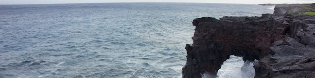
Hawai‘i Volcanoes National Park protects a changing landscape. This is true from the eruptive developments at Kīlauea Caldera all the way down to the ocean erosion at Hōlei Sea Arch. How much longer will this 90-foot tall bridge of basalt withstand the surf? Take a short walk – 100 yards each way – to Hōlei Sea Arch and see it while you can!
(adsbygoogle = window.adsbygoogle || []).push({});
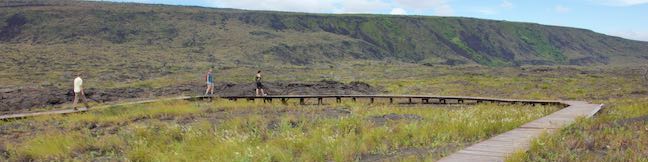
Hōlei Sea Arch is 22 scenic miles from Kīlauea Visitor Center at the bottom of Chain of Craters Road. From the end of the portion of the road that can be driven (eruptions from Kīlauea volcano have closed the rest of the road), it is a short walk to an overlook by Hōlei Sea Arch. Leave the turnaround at road’s end (by the bathrooms) and walk a few paces up the continuation of the road, which is open to hikers and cyclists. Arrive immediately at the start of the trail down to Hōlei Sea Arch Overlook. Turn right onto the trail. The short trail heads toward the edge of sea cliffs east of the sea arch. Trail’s end also boasts a fine perspective up the shoreline to the east, where punchy waves collide with the black wall of basalt sea cliffs. 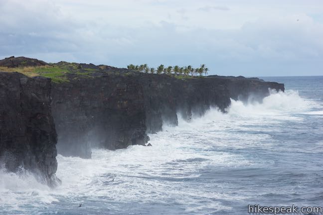
Look west to see Hōlei Sea Arch, a short distance away. The arch extends from the sea cliffs into the ocean like an elephant’s trunk. Hōlei Sea Arch is a natural bridge made of basalt. The lava for Hōlei Sea Arch came from an eruption of Kāne Nui O Hamo, a shield volcano to the northwest. Since the eruption, around 600 years ago, marine erosion provided by the ocean’s waves has slowly carved out the sea arch. How do waves create an arch? When some layers of lava are softer than others, the soft spots erode faster than the harder rock. Sometimes this differential erosion generates inspired shapes, like the natural bridge at Hōlei Sea Arch. 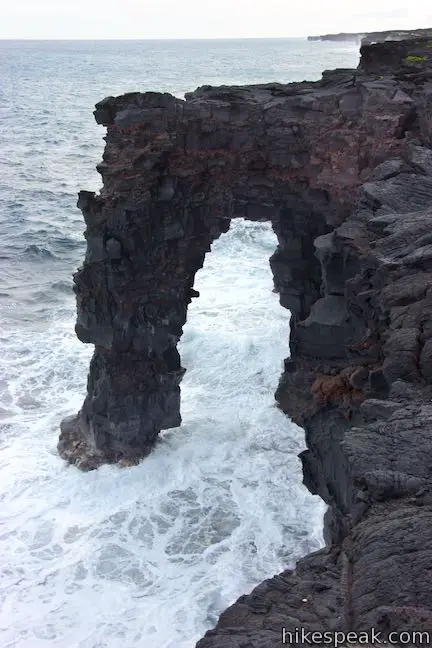
Hōlei Sea Arch is one of the park’s youngest features, having been created in the last 100 years. Unfortunately, it may also be one of the soonest to disappear. The battering waves never cease washing up the arch. How long can Hōlei Sea Arch withstand the abuse? Waves aren’t the only threat to Hōlei Sea Arch. A 2018 facebook post from Hawaii Volcanoes National Park suggests that the arch may be standing on borrowed time. “As seen in the picture, a new substantial crack is located where the arch meets the cliff. It was sustained from all of the recent earthquake activity happening on the volcano.” 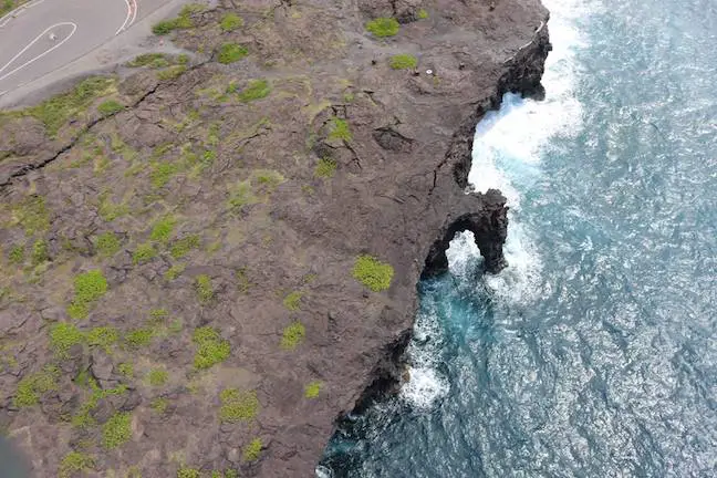
(adsbygoogle = window.adsbygoogle || []).push({});
When Hōlei Sea Arch finally does fall, it should give visitors the opportunity to observe other phases of the geological development of the coastine, becoming a sea stack or a sea cave as the basalt cliffs retreats inland. Take in views of the 90-foot tall Hōlei Sea Arch (while it stands) and then return to Chain of Craters Road for a 0.1-mile round trip hike with 15 feet of elevation change. A panel by the start of the trail explains that you are close to the start of the Hawaiian Islands:
Hōlei Sea Arch is just a small bridge in one of the world’s longest chains of islands stretching from Lō‘ihi and the Big Island past Kaua‘i to Kure Atoll, over 1,600 miles across the Pacific Ocean. As the plates shift and volcanic islands move farther from the hotspot, they grow dormant and, with the passing of enough time, erode back into the ocean. So it goes. 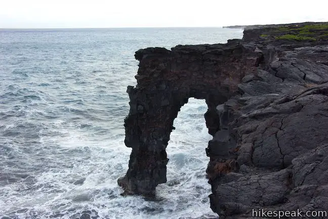
Hōlei Sea Arch Trail is open to hikers, but closed to pets, bikes, and horses. No permit is required for this hike, but an entrance fee is charged to visit Hawai‘i Volcanoes National Park.
To get to the trailhead: Take Hawaii Belt Road (Route 11) to the entrance of Hawaii Volcanoes National Park (which is 30 miles south of Hilo). The park entrance is on the left when traveling from Hilo. Drive past an entrance station to the first intersection. (Kīlauea Visitor Center is just to the right.) Turn left and drive 3 miles down Crater Rim Drive to an intersection with Chain of Craters Road and the Devastation Trail Parking Area. Turn left onto Chain of Craters Road and drive another 18.5 miles down to the Hōlei Sea Arch Trailhead at road’s end. Trailhead address: Chain of Craters Road, Hawaii Volcanoes National Park, HI 96778 from https://www.hikespeak.com/trails/holei-sea-arch-hawaii-volcanoes-np/
0 Comments
Pu‘u Loa Petroglyphs Trail puts recent geological history and human history on full display. This level 1.4-mile hike crosses a pahoehoe lava flow to a boardwalk loop through an exciting area with thousands of petroglyphs carved by early Hawaiians. The petroglyphs honor the births of those that lived here hundreds of years ago. This short trek in Hawai‘i Volcanoes National Park is sure to inspire curiosity in the not-so-distant past.
(adsbygoogle = window.adsbygoogle || []).push({});
Pu‘u LoaSet within the tapered coastal slope of a smooth pahoehoe lava flow, Pu‘u Loa is a small hill called a volcanic pressure dome. Pu‘u Loa was created during an eruption of Kāne Nui O Hamo, a shield volcano to the northwest, which produced a significant lava flow around 600 years ago, sometime between 1200 and 1450 A.D. The Pu‘u Loa Petroglyphs were carved with stone tools into the thin, hard crust of the lava flow. They bore significant meaning for the Hawaiians who carved them. Pu‘u Loa means “hill of long life.” Some 16,000 of the 23,000 petroglyphs at this site served as ceremonial vessels for umbilical cords after children were born. That‘s right – umbilical cords were placed inside carved depressions and then covered with rocks so that the mana of Pu‘u Loa would honor the children with long lives – hence “hill of long life.” The lineage of thousands of Hawaiian families is connected to this spot. Pu‘u Loa TrailReaching the Pu‘u Loa Petroglyphs requires a short walk on a single-track trail that ventured northeast from Chain of Craters Road. The trailhead is 2.5 miles from the end of Chain of Craters Road by the Hōlei Sea Arch. Puna Coast Trail departs from the south side of the road across from Pu‘u Loa Trail. Don’t take this trail (unless you are looking for a much longer hike). Make sure to set out on Pu‘u Loa Trail from the north side of the road (which will be on your left as you drive down Chain of Craters Road from Crater Rim Drive). 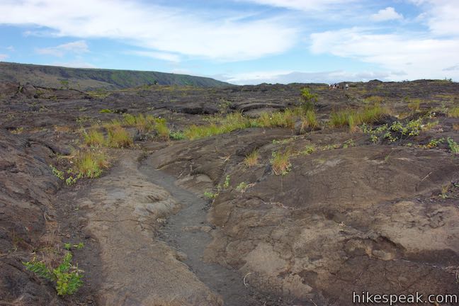
The hike to the Pu‘u Loa Petroglyphs takes you on a mostly level, but gently rolling walk across a pahoehoe lava flow. Thankfully for your footwear, pahoehoe is the smooth and ropy type of lava rock, so your passage will not be too arduous. Because the route is sometimes difficult to distinguish from the rest of the volcanic landscape, the path of the trail is marked with periodic rock piles. Admire the way the lava formed along the trail. The steep side of Hōlei Pali rises dramatically to the north. (This is the escarpment of volcanic rock that you drove down to reach the trailhead.) This hike is about 150 feet above sea level, offering glimpses of the ocean to the south. 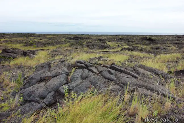
After a third of a mile of hiking, come to an info panel along the trail. If the start of the hike has you wondering – how did people live in this tough landscape? – the panel explains:
Look at the landscape around the trail. Can you imagine gardening here? Continue up the trail, admiring the small details in the volcanic landscape around you. Attentive hikers will start to see circles and other carvings in the rocks. Taking rubbings, or otherwise marring or defacing the petroglyphs is illegal. Leave everything as you find it. Proceed up the trail to the start of a boardwalk loop, 0.6 miles from the trailhead. A pair of panels along the loop help to answer a couple questions that you might have about the petroglyphs all around the boardwalk. How were the petroglyphs carved?
Why were the petroglyphs carved? The petroglyph field is filled with depressions used for a distinct, recorded purpose. These depressions are called puka and were used in rituals for newborns as containers for piko, umbilical cords. The panel includes a description by a Hawaiian named Minnie Kaawaloa who shared her connection to this site:
Hawaiian parents like Minnie hoped that the mana of Pu‘u Loa, its spiritual guiding energy, would bless their children with long, full lives. The puka also rooted each child to the ancestral lands. Look around the petroglyph field at the many different puka. Each hole was created to hold the piko of a single child. Sixteen thousand piko-related carvings have been counted at Pu‘u Loa. The petroglyph area feels like something-the-opposite-of-a-cemetery, celebrating the beginning of life, while connecting family and place. 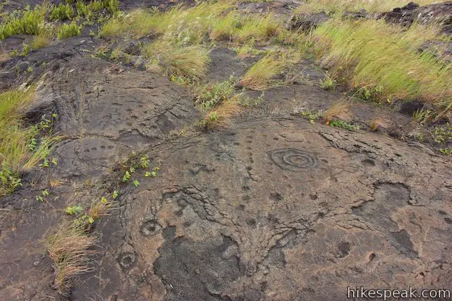
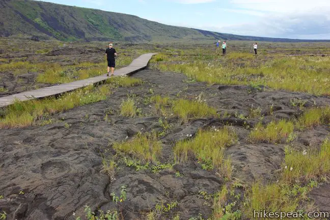
Pu‘u Loa Petroglyphs BoardwalkTake the wooden boardwalk on a loop through the Pu‘u Loa Petroglyph Field – a large, dense collection of petroglyphs. The loop in the boardwalk is 0.2 miles long and can be hiked in either direction. Clockwise seems to be the most popular route. Stay on the boardwalk and do nothing to disturb the petroglyphs. As you circle the boardwalk, notice how the piko puka (depressions for umbilical cords) come in many forms along the path. Some are deeper and some are wider. Some holes are in alignment, while others are wrapped by rings. Also among the piko puka are petroglyphs that look like people and others that form mysterious shapes. Although much of their meaning may be lost, the significance of the petroglyphs is obvious. Anything carved in stone must have been considered worth preserving. 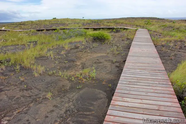
(adsbygoogle = window.adsbygoogle || []).push({});
After completing the loop on the boardwalk, and once you’ve taken time to see everything that you came to see, return down Pu‘u Loa Trail. It is a 0.6-mile hike back across the lava field to the trailhead to complete this 1.4-mile hike with 25 feet of elevation change. Pu‘u Loa Trail is for hiking only. Dogs, bikes, and horses are not allowed. Defacing the petroglyphs in any way is illegal. This is a hands-off hike. A sign at the trailhead also warns that “volcanic fumes are hazardous to your health and may be life threatening. Do not enter this area if you are a person at risk: respiratory problems, heart problems, pregnant, infants & young children.” Those with concerns can get more information at the Kīlauea Visitor Center. This hike has no shade and may be quite windy, so plan appropriately. No permit is required for Pu‘u Loa Petroglyphs Trail, but an entrance fee is charged to access Hawai‘i Volcanoes National Park.
To get to the trailhead: Take Hawaii Belt Road (Route 11) to the entrance of Hawaii Volcanoes National Park (which is 30 miles south of Hilo). The park entrance is on the left when traveling from Hilo. Drive past an entrance station to the first intersection. (Kīlauea Visitor Center is just to the right.) Turn left and drive 3 miles down Crater Rim Drive to an intersection with Chain of Craters Road and the Devastation Trail Parking Area. Turn left onto Chain of Craters Road and drive another 16 miles down to the Pu‘u Loa Trailhead, 2.5 miles from the end of the road at Hōlei Sea Arch. Trailhead address: Chain of Craters Road, Hawaii Volcanoes National Park, HI 96778 from https://www.hikespeak.com/trails/puu-loa-petroglyphs-trail-hawaii-volcanoes-np/
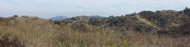
The mountain named Cerro San Luis is one of the top places to hike in San Luis Obispo, and its trailhead is actually in walking distance from downtown SLO. If you’re drawn to the large white “M” on the side of the mountain, you’re in luck! Not only is the “M” reachable as an extension of the hike to the summit, but thanks to trail created in 2017, hikers can touch the “M” at the top of a loop. Combine the “M” Trail with Lemon Grove Loop Trail for a 2.4-mile hike with 560 feet of elevation change (with options to extend this hike to 3 miles or more).
(adsbygoogle = window.adsbygoogle || []).push({});
Set out from the Marsh Street Trailhead, just north of Madonna Inn and west of Highway 101 and downtown. Get underway up a grassy slope below Cerro San Luis. After a tenth of a mile, come to a junction where the loop in Lemon Grove Loop Trail begins. If you plan to summit Cerro San Luis, it’s easiest to bear left toward Cerro San Luis Trail, which passes the “M” Trail, 0.3 below the “M” (adding adding 0.6 miles to the 4-mile round trip hike up the mountain). Venturing left up to the “M” and back is just 1.9 miles round trip. You could also bear left to hike the Lemon Grove & “M” Trails Loop in a clockwise direction. However, the directions offered here travel in the opposite direction for a more gradual approach. 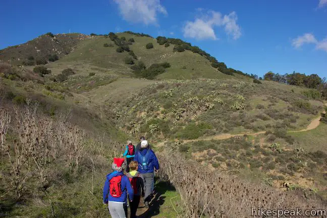
Lemon Grove Loop TrailAfter a right turn at the first junction, Lemon Grove Loop Trail weaves across an undulating grassy slope, dipping into draws and cresting rounded ridges. Prickly pear cacti dot outcroppings along the slope. San Luis Obispo spreads out to the right. Look northeast across downtown toward the Santa Lucia Mountains. Gaze southeast toward ranches and vineyards of Edna Valley. At the next junction, 0.7 miles from the start, before the trail meets a grove of eucalyptus trees, bear left up a wide dirt trail named Carriage Road. Note: If you skip Carriage Road and continue around the north end of Lemon Grove Loop Trail, this hike can be extended by 0.6 miles. Carriage Road goes through two curves like an “S” with views up toward the “M.” The wide trail quickly meets the upper half of Lemon Grove Loop Trail. Cross the trail and rise into the lemon grove that gives the loop its name. Young lemon trees are growing in this historical grove. Have a seat on a bench and gaze across San Luis Obispo toward Edna Valley. 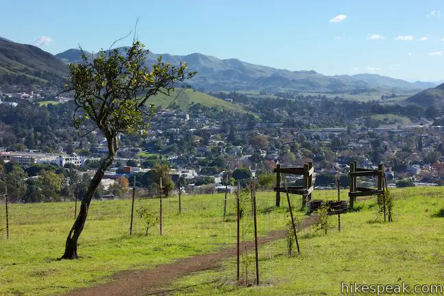
“M” TrailThe “M” Trail begins from the back of the grove, slipping into an oak woodland. The trail ascends Cerro San Luis, initially flirting along the boundary between the trees and the grasses. Look down on Lemon Grove Loop Trail crossing the slopes below. Gaze north up Highway 101 toward the Santa Lucia Mountains. Cal Poly stands out to the north and the rock mass of Bishop Peak appears as well. 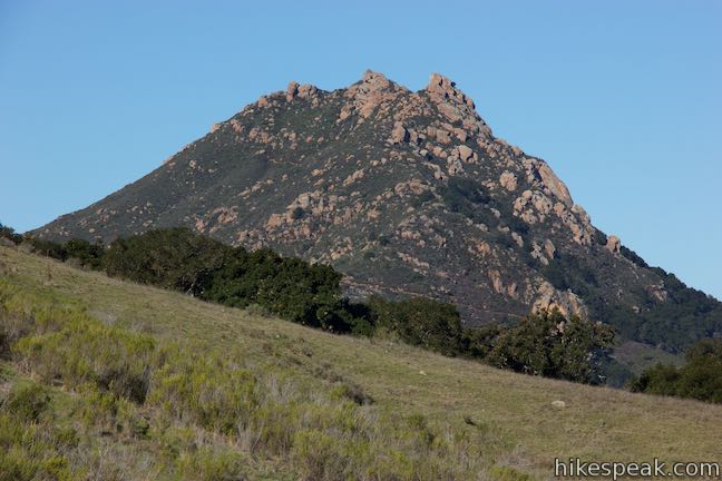
Eventually, the trail commits to the forest and leaves the fields behind. Wind up switchbacks on a rocky slope shaded by live oaks. Several wooded platforms provide gradual turns as the trail cuts up the steep mountainside (making the route suitable for bikes). 
Ascend out of the oaks to an exposed slope with more San Luis Obispo views. Ease through trees one more time, walking over a wooded platform around a rock outcropping that feels like it is floating off the side of the mountain. The impressively built trail then aims right toward the “M.” Above the “M”Immediately before you hit the large white letter, the trail passes an unmarked junction. An unmaintained path on the right ascends toward the summit. If you choose to go up the mountain this way, the directions are: bear left at a split (0.1 miles), pass a swing in a tree (0.15 miles), meet a wide trail and turn left (0.25 miles) to reach the summit (0.65 miles). For the Lemon Grove & “M” Trails Loop, skip past the steep path and enjoy a close look at the “M” with views over San Luis Obispo. 
The Cerro San Luis “M”The “M” on the mountainside is made of concrete and painted white. The “M” does not represent the Madonna Family, owners of property on Cerro San Luis (sometimes called Madonna Mountain). Instead, the “M” represents Mission College Preparatory High School, located in downtown San Luis Obispo beneath the mountain. Not to be outdone, a couple other area schools have letters of their own. To the north, the Cal Poly “P” can be read on Yucca Ridge. On the other side of downtown, spot “SP” on the slopes above San Luis High School. Beyond regional school pride, the views from the “M” on Cerro San Luis are broad and revealing, spreading across downtown San Luis Obsipo and its surroundings. 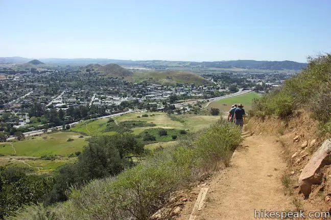
This is the high point of the hike, but just under a mile of hiking remains. Proceed southwest down the other side of “M” Trail across a sage-covered slope with nice views southeast over Edna Valley. Slip through clusters of oaks and descend into a draw where “M” Trail comes to an end at a T-junction with Cerro San Luis Trail. You will have hiked 0.3 miles down from the “M” and 0.95 miles from the start of the “M” Trail at the lemon grove. Unless you’re striving for the summit (1.35 miles up to the right), turn left to return to Marsh Street Trailhead, which is 0.65 miles away.
(adsbygoogle = window.adsbygoogle || []).push({});
Follow Cerro San Luis Trail through chaparral and oaks. Pass through a gate at the top of the grassy slopes around the skirt of the mountain. Stay to the right through a couple junctions that connect to Lemon Grove Loop Trail. Switchbacks have been built into the steep slope to make the route a little more gradual. Hike half a mile down the trail to the trailhead, passing the opening junction with Lemon Grove Loop Trail, a tenth of a mile before returning to the parking area. The basic directions for this loop are:
Hiking all of “M” Trail and some of Lemon Grove Loop Trail creates a 2.4-mile loop with 560 feet of elevation change. Skip the Carriage Road shortcut to see more of Lemon Grove Loop Trail for a 3-mile hike. Hikers are welcome to bring dogs. No fee or permit is required to hike around Cerro San Luis, so get out and enjoy! A note for mountain bikers: The “M” Trail and the top half of Lemon Grove Loop Trail are open to bikes. The city recommends that bikers take this loop in a clockwise direction (opposite of what is described above). Bikers should take Cerro San Luis Trail to the south end of the “M” Trail and ride the trail northward. At the bottom of the “M” Trail by the lemon grove, bikers should turn right on Lemon Grove Loop Trail to get back to the trailhead, rather than using Carriage Road to reach the lower side of the trail. To get to the trailhead: From downtown San Luis Obispo, take Higuera Street southeast to Marsh Street and turn right. Pass beneath Highway 101, and turn right on Fernandez Lane (the only road on the right before Marsh Street turns onto the 101 South). Turn right into the dirt parking area. The trail begins at the end of the lot. Trailhead address: 1183 Fernandez Road, San Luis Obispo, CA 93405 from https://www.hikespeak.com/trails/lemon-m-trail-loop-cerro-san-luis-obispo/
During the late teens of the 22nd century, San Luis Obispo has developed Reservoir Canyon Natural Reserve into a versatile hiking destination, with upgraded trails and features. Reservoir Canyon Trail and Summit Trail deliver great half-day hikes. However, a shorter option exists that packs Reservoir Canyon into a one-mile experience with 150 feet of elevation change. Use Creek Bypass Trail to tie the bottoms of Summit Trail and Reservoir Canyon Trail together, gaining views over riparian Reservoir Canyon, cradled below the Santa Lucia Mountain. Reservoir Creek Falls is a minute up the trail, so get going!
(adsbygoogle = window.adsbygoogle || []).push({});
As its name suggests, Creek Bypass Trail also serves as an alternate route for the bottom of Reservoir Canyon Trail, which can get wet and muddy when Reservoir Creek is flush. During stretches of winter wetness, Creek Bypass Trail becomes the recommended replacement from Reservoir Canyon Trail and this loop stops being an option. If you’re a self-disciplined hiker, you could save Reservoir Creek Falls for the end of this hike and travel clockwise up Reservoir Canyon Trail, across Creek Bypass Trail, and down Summit Trail to the waterfall and trailhead. The directions provided here take the opposite approach, immediately indulging in Reservoir Creek Falls, and then crossing Creek Bypass Trail toward Reservoir Canyon Trail, in the directions that seems to maximize the trail’s views for hikers. 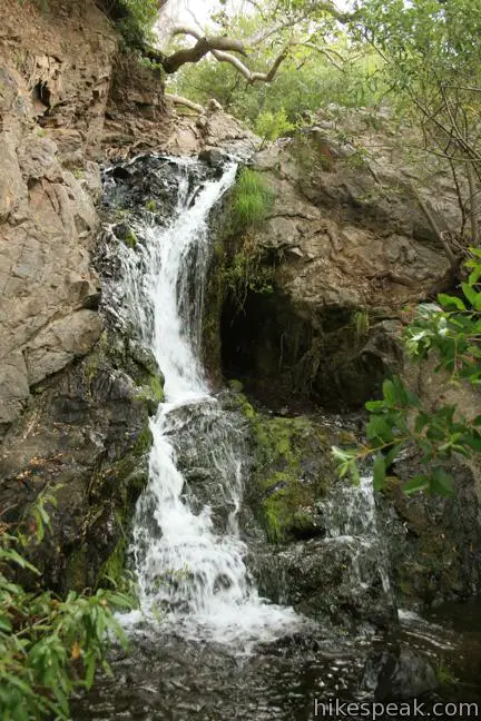
The basic directions for this loop are:
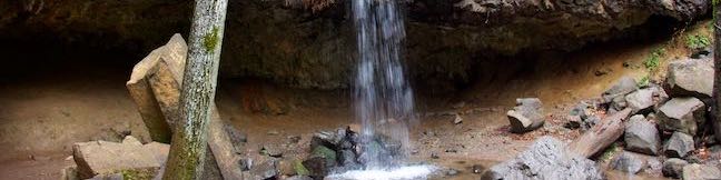
Make your way to the large (new) parking area at the Reservoir Canyon Road Trailhead. At the east side of the parking area, and a straight shot off the end of the road, is a gate at the beginning of Reservoir Canyon Trail. Use this trail to finish the loop. Begin instead beside the kiosk at the west end of the parking area. Walk through grasses into the woods beside Reservoir Creek. Rising in front of you is Reservoir Creek Falls, measuring some fifteen or twenty feet tall. The charming waterfall slides down a slope of black rock into a shallow oak-shaded pool. This waterfall nearly disappears during dry months, but is plenty enjoyable when water is flowing. A tunnel on the right side of the waterfall is a remnant of the old reservoir in the canyon. The tunnel served as an outflow for the dam. From the waterfall, proceed up the slope on the left side of the falls. Rise to a junction and turn right onto a bridge that spans Reservoir Creek above the falls. Cross the bridge and follow Summit Trail through dense oaks and toyon on the opposite bank. This nicely established single track rises up the side of Reservoir Canyon through a few turns and switchbacks. 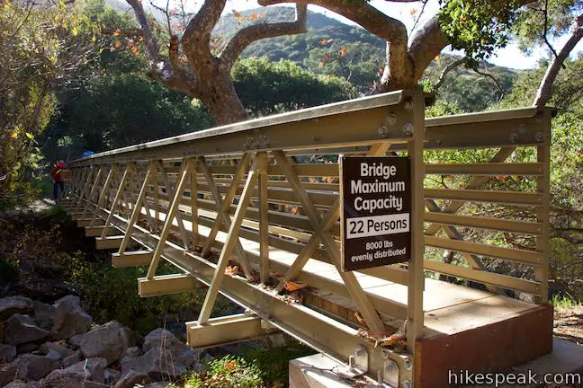
Follow Summit Trail for 0.2 miles up to Creek Bypass Trail. Don’t get fooled by another path parting to the left, 150 yards up the trail, which is barricaded off and is not the trail you seek. At the next switchback to the left, avoid a small path on the right (this may be a junction for future trail development). Rise through more live oaks to the marked junction. Stop climbing up Summit Trail, toward the tower on the ridge above, and turn left onto Creek Bypass Trail. Creek Bypass Trail levels out and crosses a slope covered in grasses and low brush. The vegetation presents open views north toward the Santa Lucia Mountains (where hikes on West Cuesta and East Cuesta depart from the Highway 101. 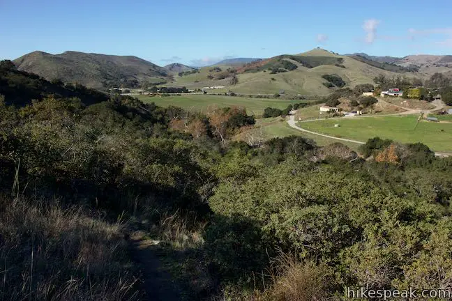
After about 100 yards on Creek Bypass Trail, and 0.3 miles from the trailhead, put the hiking on pause as the trail curves to the right atop a bend in Reservoir Canyon. Stop beside a rock outcropping and absorb a sweeping perspective over Reservoir Canyon. Look out from the viewpoint over the trees growing along the bottom of the canyon. Grass and chaparral-covered slopes frame the canyon, rising into the mountains north of San Luis Obispo. 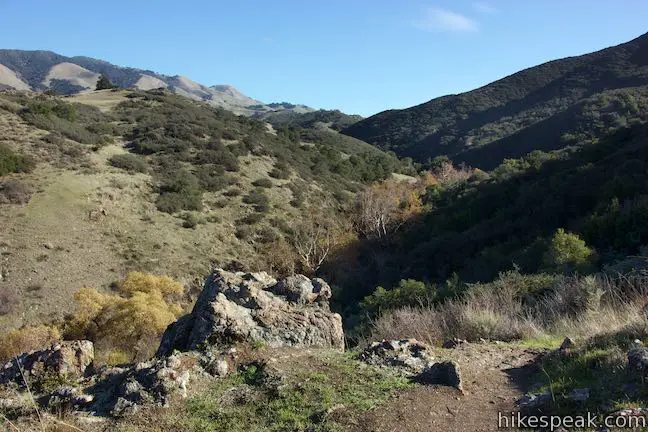
Continue along Creek Bypass Trail, which crosses below cliffs of exposed rock on the wall of the canyon. Cross a gully where a drainage flows down the side of the canyon. When an unmarked path descends to the left, continue straight along the main trail. Oaks appear beside the trail, ushering you down into the canyon. Return to the shade, arriving at stone steps that swing down to the canyon bottom. Cross the creekbed to a T-junction with Reservoir Canyon Trail.
(adsbygoogle = window.adsbygoogle || []).push({});
To the right, Reservoir Canyon Trail pushes farther up the canyon to the ridge above. If you are using Creek Bypass Trail to bypass wet areas lower in the canyon, bear right and venture up the canyon. For the 1-mile loop, turn left down Reservoir Canyon Trail. Reservoir Canyon Trail passes between the trees sheltered along the creek and the grassy slope on the side of canyon. The trail is wide, but narrows in places where it twists through crossings of Reservoir Creek (where the trail can get washed out after rainstorms). The level trail slips through the shade of sycamores, oaks, and assorted brush. Reservoir Canyon Trail widens into an old municipal road, a remnant from the canyon’s former purpose as a reservoir for San Luis Obispo. Just before the trailhead comes into view, cross a junction with a trail parting to the left. By turning here, you would quickly reach the bridge across the creek for Summit Trail and the route down to Reservoir Creek Falls. Unless you’re compelled to see the waterfall again, simply walk straight through this last junction. The trail ends at the east side of the parking area where you began, completing the 1-mile loop on Summit Trail, Creek Bypass Trail, and Reservoir Canyon Trail. No fee is charged to park at the Reservoir Canyon Road Trailhead and no permit is needed to hike in Reservoir Canyon Natural Reserve. Dogs are welcome on leashes but bikes are not permitted. Reservoir Canyon Natural Reserve (formerly Bowden Ranch & Reservoir Canyon Open Space) preserves 783 acres. To spend more time in this city of San Luis Obispo reserve, explore Reservoir Canyon Loop. To get to the trailhead: From downtown San Luis Obispo, take Highway 101 north for approximately two miles to Reservoir Canyon Road (an easy-to-miss road connecting to the freeway). Turn right and drive half a mile to the trailhead parking area at road’s end. After the hike, exercise caution when getting back on the highway. It may be safer to drive north and turn around at another exit rather than cutting across northbound traffic to reach the southbound lanes to San Luis Obispo. Trailhead address: Reservoir Canyon Road, San Luis Obispo, CA 93401 from https://www.hikespeak.com/trails/reservoir-canyon-creek-bypass-trail-loop/
Hedge Creek Falls is a 35-foot waterfall pouring over a basalt overhang into a wooded ravine above the Sacramento River south of Mount Shasta. A short trail leads to the waterfall from a trailhead right beside an Interstate 5 offramp in Dunsmuir, so this waterfall hike makes a great break from highway travel. The fun trail actually passes behind the waterfall, going underneath the overhang, and continues down to a Sacramento River Overlook, resulting in a never-a-dull-moment 0.6-mile round trip hike with 130 feet of elevation change.
(adsbygoogle = window.adsbygoogle || []).push({});
Need a break while driving on I-5? Get off at exit 732 in Dunsmuir, 6 miles south of Mount Shasta. Right at the end of the offramp, find trailhead parking at the corner of Siskiyou Avenue and Dunsmuir Avenue. How convenient is that? Walk across Dunsmuir Avenue to a dirt trail going into the forest, passing a sign shaped like a train locomotive that reads, “Welcome to Hedge Creek Falls” (you could see an actual train at the end of the trail). Walk 50 yards to a pavilion on the edge of the ravine and bear right down the single track marked Hedge Creek Falls Trail. Descend across a slope through firs and outcroppings of mossy boulders. 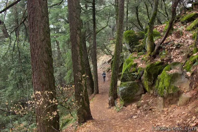
After a tenth of a mile, come to a switchback bending to the right that offers a bench for taking an early break (the bench might prove more useful if you’re short of breath on the hike up). Look beyond the bench and try to catch a glimpse of Hedge Creek Falls. After doubling back for about forty yards, the trail turns through another switchback and resumes its trajectory heading northeast. Hedge Creek appears in the ravine below, peacefully tumbling toward the Sacramento River. In no time at all, the waterfall leaps out in front of you. Hedge Creek Falls spills over a thick ledge of columnar basalt and then continues to plunge through an open-air fall into a basin in the ravine. 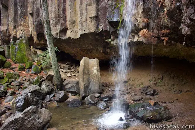
The trail takes you straight to the waterfall, but it doesn’t stop there! A crescent-shaped alcove carved out below the ledge of columnar basalt creates the space to walk all the way around the back of the waterfall. Take in perspectives of Hedge Creek Falls from every angle. 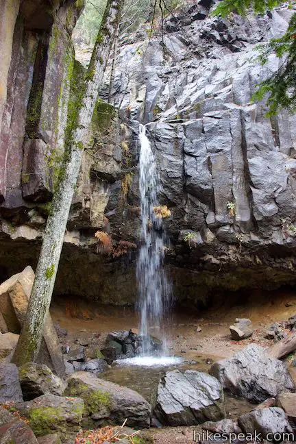
Proceeding out from the overhang, the trail continues down the opposite side of the ravine, bordering Hedge Creek for another tenth of a mile to approach a viewing platform that faces the Sacrament River. Pass another bench shortly below the waterfall. Come to the Sacramento River Overlook, 0.3 miles from the trailhead (and 130 feet lower in elevation). Look out across the Sacramento River, flowing southwest through a bend in the wooded canyon below. Across from the overlook and through a line of trees, spot the Union Pacific Railroad Line and possibly a passing train. 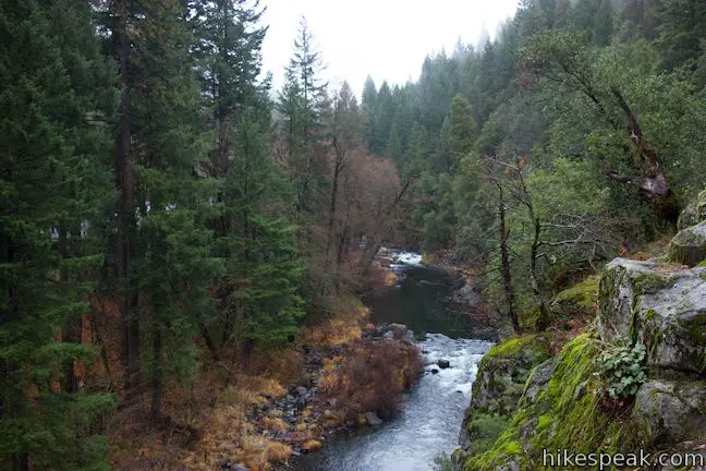
A path to the left of the overlook descends to the Sacramento River, and the prospect of summer swimming holes. Looking right, you should be able to spot Mount Shasta rising above the treetops to the north (unless unfortunate storm clouds steal your view). Footpaths sneak up a short, steep, rocky slope to the right, apparently leading to improved perspectives north toward Mount Shasta and down over the Sacramento River. Leave the overlook and hike back up Hedge Creek Falls Trail. Pass behind the waterfall a second time and pause to ponder some of its history. Hedge Creek Falls bears the nickname “Million Dollar Waterfall.” When Interstate 5 was constructed, the original plans positioned the highway right on top of Hedge Creek Falls. Protests to preserve the waterfall were victorious and the interstate’s planned path was moved. The relocation added around million dollars in construction costs, and gave birth to the nickname. A million thank-yous… 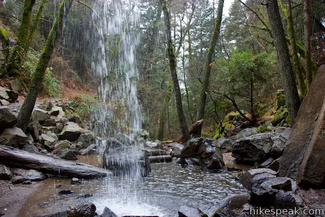
(adsbygoogle = window.adsbygoogle || []).push({});
If the overhang behind Hedge Creek Falls seems like a decent place to hunker down for the night, you wouldn’t be the first to have that idea. It is believed that stagecoach robber Black Bart hid behind the waterfall before holding up a stage. Part with Hedge Creek Falls and hike the final 0.2 miles up to Dunsmuir Avenue to complete this outing. Watch out for poison oak along the trail. Dogs are welcome. No permit is required for this hike and parking at the Hedge Creek Falls Trailhead is free, so get out and enjoy! To get to the trailhead: From Mount Shasta, travel south on Interstate 5 for about 6 miles to exit 732. At the end of the offramp, turn right on Siskiyou Avenue. Then make an immediate right on Dunsmuir Avenue. Pull into the parking area on the right side of the road. Use to crosswalk to reach the Hedge Creek Falls Trail on the opposite side of Dunsmuir Avenue. From Redding, take Interstate 5 north for 53 miles to exit 732. At the end of the offramp, turn right on Siskiyou Avenue. Cross under the interstate and turn right on Dunsmuir Avenue. Then park in the area on the right. Trailhead address: Parking for Hedge Creek Falls, 506 Dunsmuir Avenue, Dunsmuir, CA 96025 from https://www.hikespeak.com/trails/hedge-creek-falls-dunsmuir/
The Santa Monica Mountains have significant parks with great hiking getaways. Often overlooked are smaller undeveloped pockets within the mountains that offer quick escapes from the stresses of Los Angeles. Longridge Park in Sherman Oaks is the latter, a 50-acre park with a 0.2-mile long use-trail. Longridge Trail has ridge-top views throughout its short run, like perspectives north across the San Fernando Valley and east toward the Griffith Park end of the range. Another trail highlight is an outcropping of sandstone with striped layers. You won’t burn a lot of calories on this 0.4-mile round trip hike with 75 feet of elevation change. However, if you’re satisfied with short and sweet, Longridge Park is plenty fun. 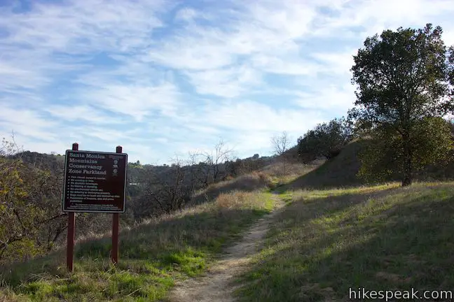
Longridge Park is located on the north side of the Santa Monica Mountains in Sherman Oaks, between Dixie Canyon Park and Coldwater Canyon Park. Use roadside parking and set out from the top of Alomar Drive (south of Ventura Boulevard and west of Coldwater Canyon Avenue). A dirt single track leaves from the end of the road, quickly passing a sign to announce that you are entering a Santa Monica Mountains Conservancy Zone Parkland.
(adsbygoogle = window.adsbygoogle || []).push({});
Begin up the trail, passing a cluster of live oaks on the right. The trail quickly swings to the right, going up a rise on the ridge. As the trail turns, it passes a narrow path on the left. For those unopposed to scraping through the sagebrush, this path could be used to form a loop and explore farther in the park. Continue up the trail onto the spine of the ridge, where it curves to the left past an excellent early viewpoint, a hundred yards from the start. Pause to look west over Dixie Canyon and north across Sherman Oaks and other cities in the San Fernando Valley. The Santa Susana Mountains and San Gabriel Mountains rise to the north. 
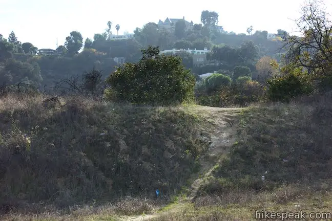
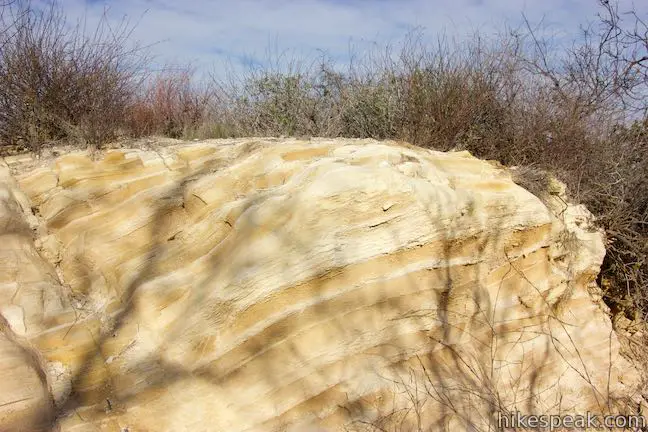
Longridge Trail ventures south up two leveled terraces in the ridge. After the second short but steep step in the terrain, cross a field and approach an unmarked junction in front of a shallow trough. One branch of the trail goes to the right, snagging additional views over Dixie Canyon, while the other half of the trail goes straight ahead. Proceed straight for a moment and then look underfoot and off the left side of the trail to observe areas of exposed bedrock with stylish stripes. An upturned crest in the bedrock reveals sandstone that is layered in different shades of yellow and tan. While this is no Fire Wave, it’s certainly a fun feature. 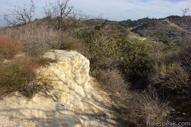
Leave the outcropping, 1/8 of a mile from the start, and continue up either branch of Longridge Trail (they quickly reunite). Come to another small clearing where the trail seems to splinter and end. Don’t despair. Proceed up a thinner trail along the west side of the ridge top (keeping the taller brush to your left). March through grasses, looking south up the ridge toward mansions along Mulholland Drive. Approach a longer clearing, 0.2 miles from the start, which boasts nice views of the surrounding Santa Monica Mountains. Look over a saddle in the ridge to the east to see the tops of Cahuenga Peak and Mount Lee in Griffith Park. 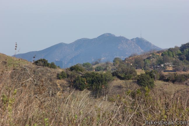
To the south, the trail becomes even thinner and harder to trace as it runs into dense sagebrush. Unless you uncover an easy way to advance or dip below the east side of the ridge to loop back to the start (future trails may be developed in the park), it is probably best to turn around at the clearing with the Griffith Park views.
(adsbygoogle = window.adsbygoogle || []).push({});
Although it might feel like you’ve just gotten going, this is the end of the trail! Turn around and hike back through Longridge Park. Ease down the ridge, enjoying broad views across the San Fernando Valley, and return to Alomar Drive. Longridge Park is operated by the Mountains Recreation and Conservation Authority. The park is open from sunrise to sunset. Dogs are permitted on leashes. Bikes also appear to be allowed. Please pack out all trash (far too much garbage has been dropped along the trail). No fee or permit is required for this hike, so get out and enjoy. To get to the trailhead: Take the 101 Freeway to exit 15 for Coldwater Canyon. At the end of the offramp, turn south on Coldwater Canyon Avenue. Drive 3/4 of a mile to Ventura Boulevard and turn right. Drive one block and turn left onto Valley Vista Boulevard. Drive 0.2 miles and turn left up Mary Elle Avenue (the 4th left). Go one block, cross Longridge Avenue, and continue up Alomar Drive. Make a left turn at an intersection with Cheltenham Drive to follow Alomar Drive for 0.6 miles up to the trailhead at road’s end. By mass transit, take either LA Metro bus line 150, 240, or 750 to the Ventura / Valley Vista stop along Ventura Boulevard. Walk a little under one mile from there up to the trailhead. Trailhead address: 3600 Alomar Drive, Sherman Oaks, CA 91423 from https://www.hikespeak.com/trails/longridge-park-sherman-oaks-los-angeles/
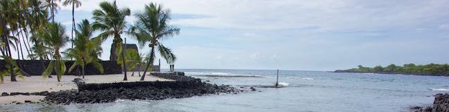
To walk through Hawaiian history, head to Pu‘uhonua O Hōnaunau National Historical Park, located on the west coast of the Big Island of Hawai‘i, south of Kona. A convenient hiking trail weaves through the park’s Royal Grounds and the Pu‘uhonua (place of refuge). This half-mile long loop passes sixteen numbered markers that correspond with entries in a park brochure to put an educational spin to the scenic surroundings.
(adsbygoogle = window.adsbygoogle || []).push({});
Set out from the visitor center and walk down toward the coast. Leave the concrete and step onto a pale, crushed rock surface at a three-way junction. One end of the loop is to the left. Another path goes straight. Ignore both and bear right to begin the counter clockwise loop. The first marker announces that you are on the royal grounds. Be respectful of this sacred site, which was used by ali‘i (Hawaiian chiefs) as a place to host important gathering and ceremonies. Hōnaunau was the home of Kona’s chiefs and the ancestral grounds of the Kamehameha dynasty. Hiking the Royal GroundsWalk toward the coast, passing a scaled-down model of the Hale o Keawe temple on the right. You will see the actual temple midway through the loop, but won’t be able to step inside. The recreation is still plenty large, with a thatched roof made of ki leaves. Straight ahead, find another smaller structure next to the coast. Looking north, people may be visible swimming in a cove just beyond the park boundary. Swimming and snorkeling are not allowed within the royal grounds or pu‘uhonua, but the boat launch and snorkeling area along Honaunau Beach Road just outside the park appear to be quite popular. 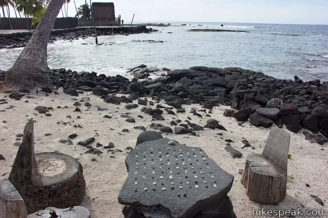
Curve to the left and approach the next few markers. Marker 3 is placed beside a lava rock game board with black and white pieces. This Hawaiian strategy game is called kōnane. The playing surface, called the papamū, can vary in size. Instructions for kōnane should be available at the visitor center. Beside Marker 4, look at bowls carved into lava rock. Resembling the morteros used by Native Americans in the American southwest, these rock bowls are called kānoa and may have been used to dye bark cloth, tan fishing nets, or make ceremonial drinks. For another lava-formed feature, check out marker 5, where tree molds appear in lava rock in places where palms once stood. The corresponding entry in the brochure explains:
The trail swings around Keone‘ele Cove (marker 6). This significant cove was reserved for the canoes of chieftains. The brochure asks you to picture paddlers maneuvering canoes around lava rocks in the bay to bring the ali‘i, priests, and advisors ashore in the cove. This VIP area is now reserved for the sea turtles (honu), who drift through the water and hide in the sand along the shore. Admire the sea turtles from a respectable distance. 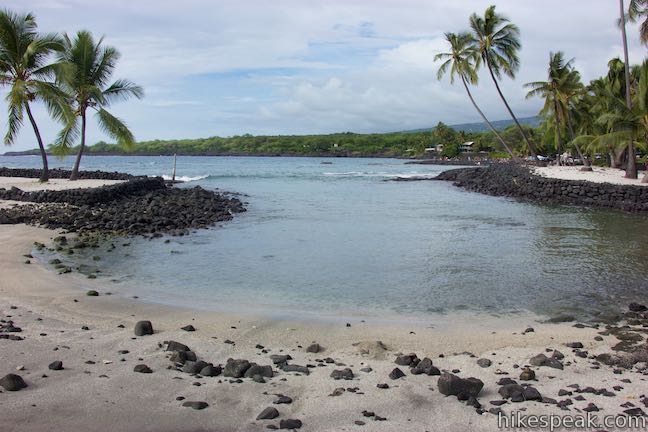
Behind the cove is a fishpond, which you’ll pass later in the loop. For now, continue around the cove through a cluster of coconut palms and approach a long black wall made up of lava rocks. 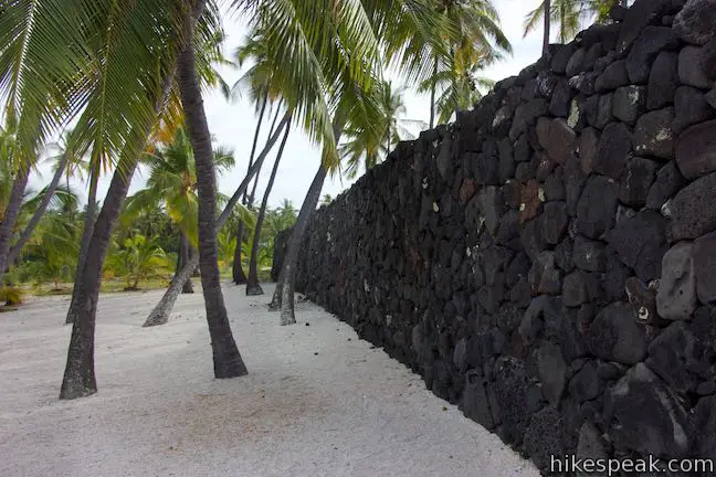
The Great Wall and the Hale o KeaweThe great wall made of lava rocks separates the royal grounds from the pu‘uhonua, which was a place or refuge in Hawaiian culture. Within the pu‘uhonua, sanctuary and forgiveness were possible. A passage in the brochure explains that the wall was:
The dark wall stands out against the light-colored grounds. Walk to the end of the wall to the park’s main feature, the Hale o Keawe, which is fenced off and guarded by ornate wooden statues. This heiau temple is a sacred place for the Hawaiians and is a mausoleum for the remains of 23 ali‘i (chiefs). Tall statues carved in wood are called ki‘i. They represent Hawaiian gods and stand as indicators of the site’s significance. Walk right up to two of the ki‘i guardians that stand near the water’s edge. Now imagine the impression that these carvings would give off if you were arriving by canoe. 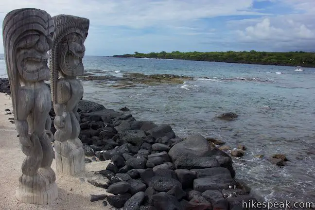
At this point, 0.2 miles from the start, you are leaving the royal grounds for the pu‘uhonua. Walk around the temple, passing tide pools on the right where tropical fish like yellow tang swim in the shallows. What was the Pu’uhonua?Under the harsh Hawaiian laws of kapu, the punishment for breaking a law was death. Some of the transgressions that could results in death, as listed in the park brochure were:
The only way to avoid punishment was to elude pursuers, run to the coast, and swim to a pu’uhonua. Those who pulled off this feat could be absolved by kahuna pule (priests). After a short time in the refuge, law-breakers that were pardoned by priests would be able to return home. During wars, pu’uhonua around Hawaii served as outside-the-battle safe spaces for children, elders, and other non-fighters. When wars ended, people from the losing side might seek the sanctuary of the pu’uhonua as well (instead of facing death). Within the walls of a pu’uhonua, no physical harm could come to you.
For centuries, the pu’uhonua provided threatened Hawaiians with a second chance at life, until the kapu laws were abolished in 1819 by King Kamehameha II, the second ruler of the unified kingdom of Hawaii. Today’s visitors no longer need to escape death sentences and be pardoned by priests in order to enjoy the calm refuge of the pu’uhonua. 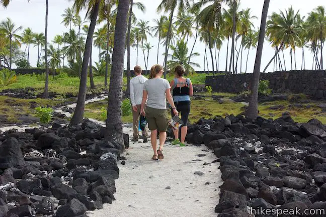
Hiking through the Pu’uhonuaA rugged coastline of dark lava rock and tide pools spreads out to your right as you follow the pale trail southward into the pu’uhonua. A hundred yards from the Hale o Keawe, come to a spur path on the right that leaves the loop trail. The path leads around the rock wall of a heiau, called the the ‘Āle‘ale‘a, which likely predates the Hale o Keawe, and was used by ali‘i as a platform for watching hula. At the end of the spur path, spot marker 10 beside the Keōua Stone. This block of volcanic rock was a resting place for a high chief. Notice four holes in the ground around the rock, which likely supported a shade canopy. Imagine yourself as Keōua, gazing out over the blue bay and the black shoreline. Backtrack to the junction and turn right to continue on the loop trail along the rock wall of the heiau. Approach a large boulder of dark red lava. It is believed that Queen Ka‘ahumanu hid under this impressive stone during a quarrel with King Kamehameha. The trail passes marker 13, where another rock has a carved depression laid out in a papamū board for playing kōnane. Enjoy coastal views on the way to the next marker, at the site of a temple build long ago. Although this old heiau is hard to see, the remnants are believed to be some of of the oldest structures in the park. The trail now turns inland, weaving toward a forest of palms. Standing out from this natural scene is the black boundary of the great wall. Pass a small pond as you approach the wall. This type of pond is called an anchialine pool, because it is fed by both freshwater springs and ocean water. Continue along the trail toward a modern opening built through the wall, which allows easy passage back to the royal grounds. Return to the Royal GroundsThe loop trail passes two more numbered markers as it progresses back toward the visitor center. At marker 15, ease between two royal fishponds located behind Keone‘ele Cove. These anchialine pools were used for fish farming. According to kapu, fish harvested from the ponds could only be eaten by the ali‘i. 
Just before the visitor center, pass a pair of tall wooden structures with thatched roofs. These hālua serve as boathouses for wa‘a, traditional Hawaiian canoes. Step inside the hālua and you may find artisan Hawaiians getting crafty with natural materials like coconut husks.
(adsbygoogle = window.adsbygoogle || []).push({});
Leave the hālua and close out the loop. When you get back to the start, turn right and walk back through the visitor center to the parking area. For additional hiking in the park, consider the 1871 Trail venturing south down the coast. No permit is required to walk the Royal Grounds – Pu‘uhonua Loop. However, an entrance fee is charged to visit Pu‘uhonua O Hōnaunau National Historical Park (operated by the National Park Service). The fee is $15 per vehicle, or $10 or motorcycles and $7 for pediatricians and cyclists, and is valid for seven days of entry (prices as of 2019). In lieu of individual park entry fee, an America the Beautiful interagency pass may be used, as well as an annual pass eligible for three Hawaiian national parks (Hawai‘i Volcanoes National Park, Haleakalā National Park, and Pu‘uhonua O Hōnaunau National Historical Park). The park opens daily at 7 a.m. and closes 15 minutes after sunset. The visitor center is open daily from 8:30 a.m. to 4:30 p.m. To get to the trailhead: From Kona, travel south on Hawaii Belt Road (Hawaii 11) for 8.5 miles. At an intersection with Mamalahoa Highway (Route 180) stay to the right and continue on Hawaii Belt Road, following signs for Volcano. Drive 3.5 miles to Captain Cook and turn left to stay on Hawaii Belt Road at an intersection with Mamalahoa Bypass Road. Drive another 6.5 miles south on Hawaii Belt Road to an intersection with Ke Ala O Keawe Road (Route 160) and turn right, following signs for Pu‘uhonua O Hōnaunau. Traveling in the opposite direction as Kona, the intersection with Ke Ala O Keawe Road is 76 miles up Hawaii Belt Road from the town of Volcano and Hawai‘i Volcanoes National Park. Drive 3.5 miles down Ke Ala O Keawe Road to the coast and turn left at a large sign for Pu‘uhonua O Hōnaunau National Historical Park. The entrance both is a short distance down the road, followed by the parking area and visitor center. Trailhead address: Ke Ala O Keawe Road (State Highway 160), Honaunau, HI 96726 from https://www.hikespeak.com/trails/puuhonau-o-honaunau-royal-grounds-loop-hawaii/
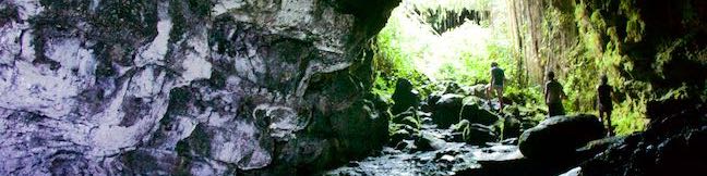
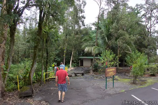
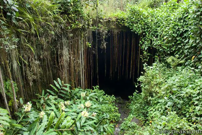
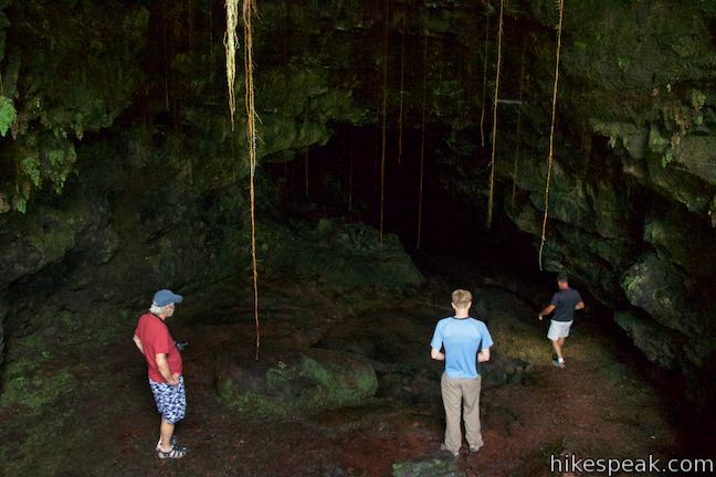
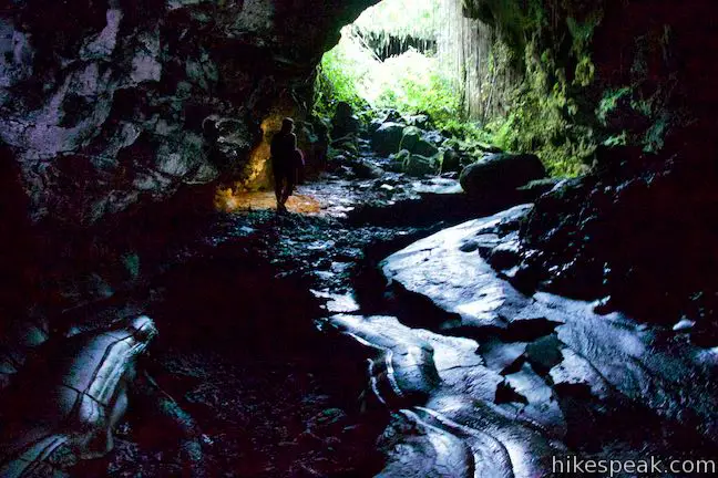
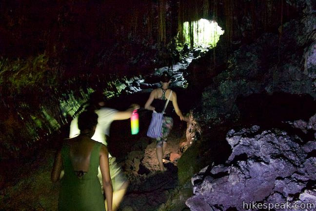
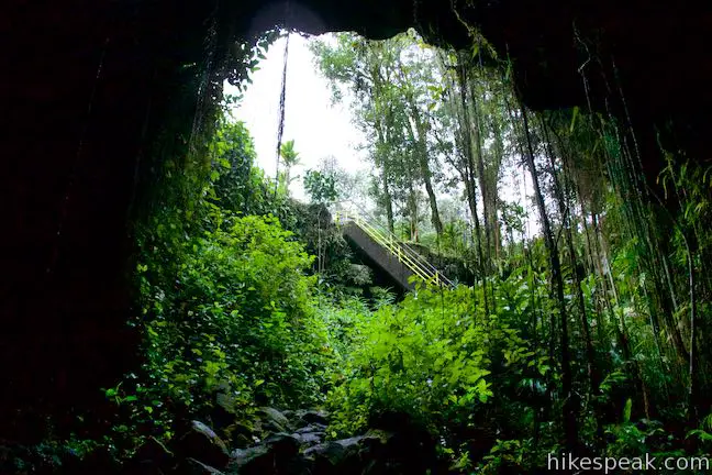
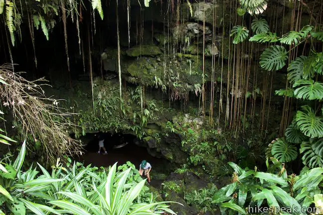
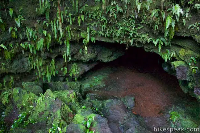
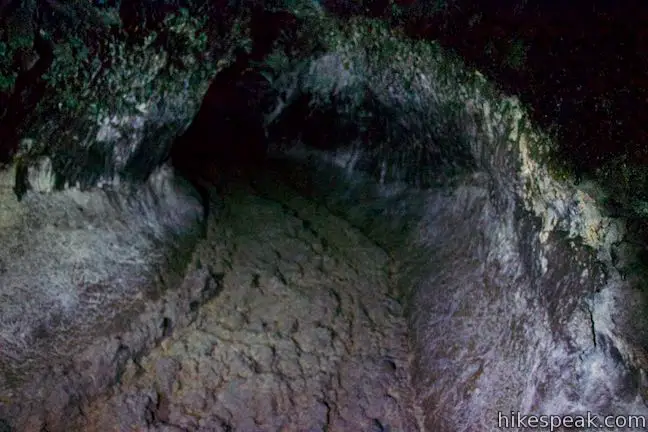
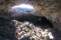
The Big Island of Hawai‘i is the type of dynamic land where you can find a lava tube on the edge of the island’s main city. An 1881 lava flow from Mauna Loa stopped just short of Hilo. Venture up and down a lava tube created by that flow. Enter through a collapsed skylight at Kaumana Caves Park and start exploring. While the entire tube may measure over twenty miles long, visitors can expect to see somewhere under two miles from the Kaumana Caves entrances. Start from a parking area along Kaumana Drive, about 4 miles from downtown Hilo. Cross the road to immediately find the access point for the Kaumana Caves. A concrete staircase with a yellow, metal railing descends into an open area where the roof of the cave collapsed. A sign beside the staircase reads:
A confusing aspect of the Kaumana Caves lava tube is that some areas are preserved as a park, while other parts of the lava tube are privately owned (below private property). Visitors are granted entry into the public area of the caves, but it is not fully apparent what sections of the lava tube are off limits.
(adsbygoogle = window.adsbygoogle || []).push({});
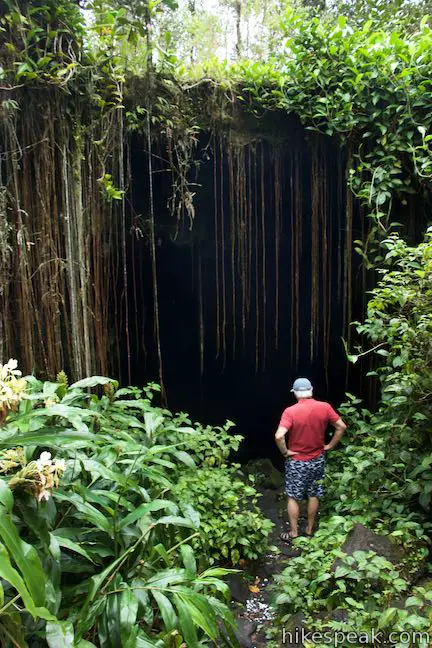
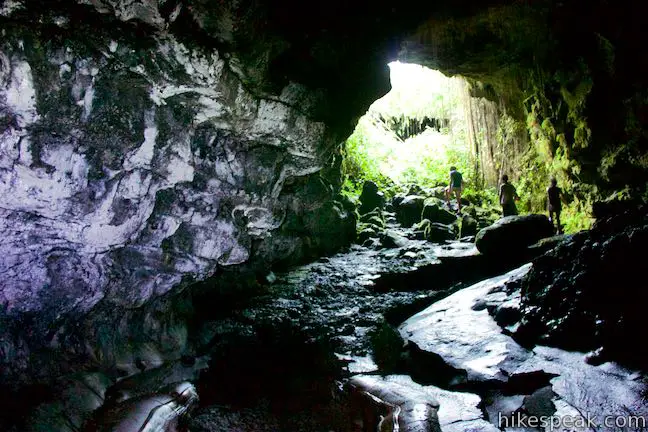
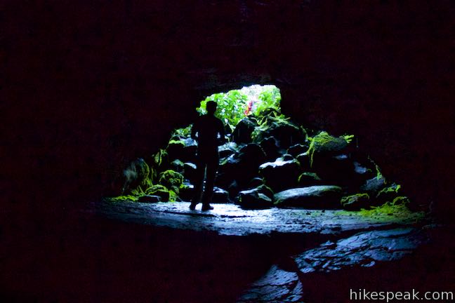
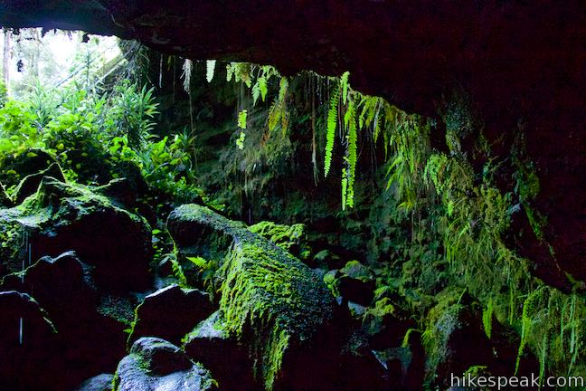
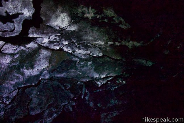
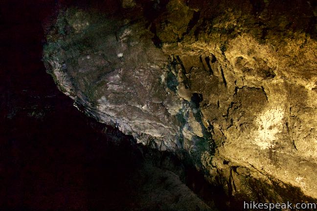
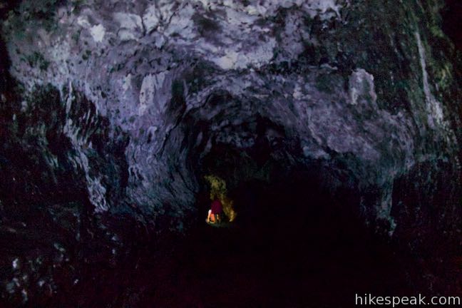
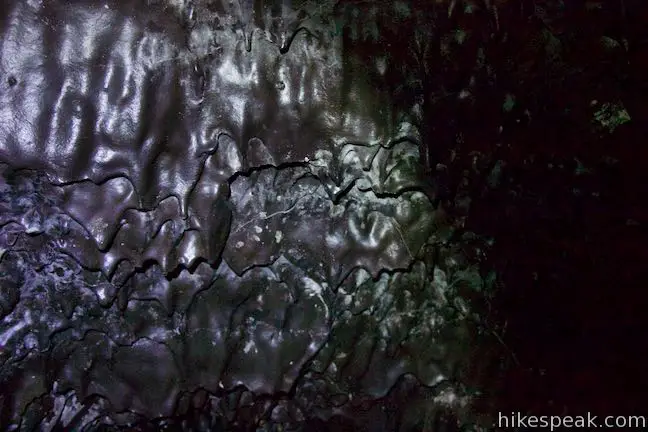
Based on the nuances of Kaumana Cave and the risks of exploring deep into cave systems, it is probably best to just turn back after venturing a satisfying distance into each side of the lava tube. The staircase leads down into a collapsed area that splits the lava tube. This skylight cradles a miniature rainforest where ferns and philodendron drape down the sides of the cave. To the left and right of the bottom of the stairs are two openings into the lava tube. 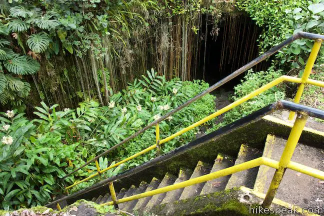
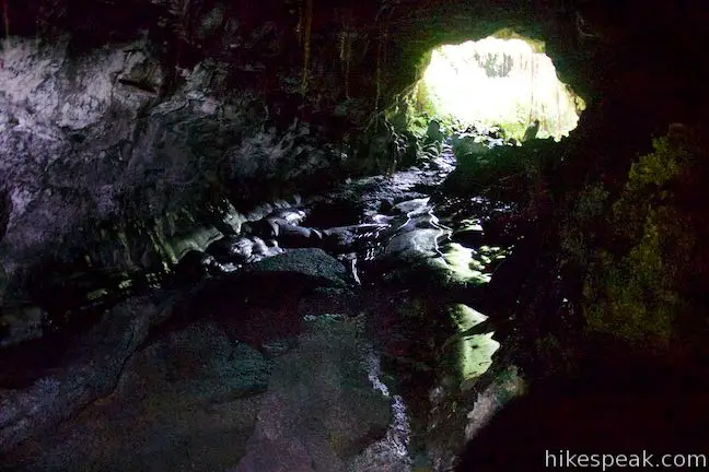
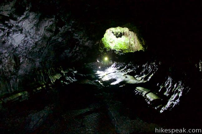
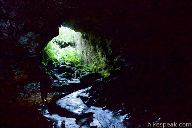
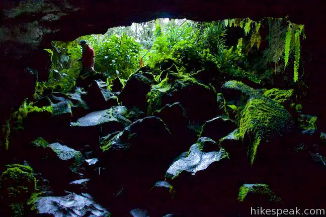
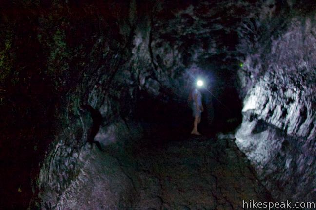
North of the entrance for Kaumana CavesTurning right at the bottom of the staircase leads to the larger of the two entrances. Walk down stone steps to a tall opening in the tube. Sunlight illuminates the front of a sizable room in the lava tube. While much is visible at first, you will quickly need to rely on flashlights to see inside the cave. 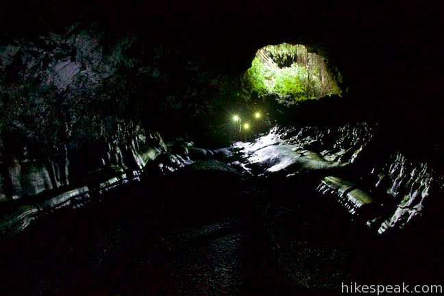
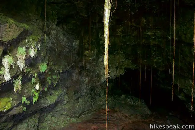
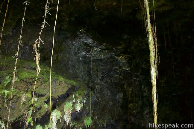
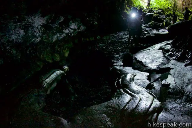
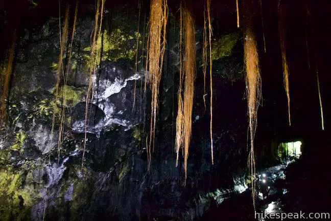
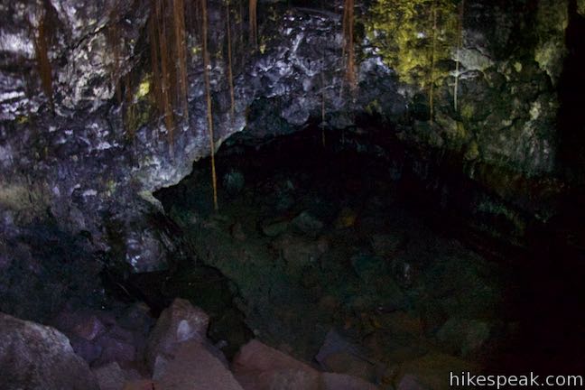
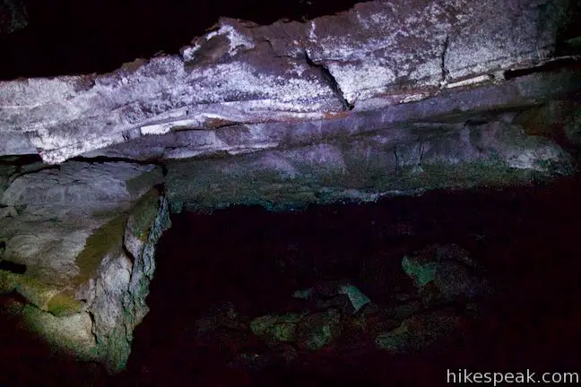
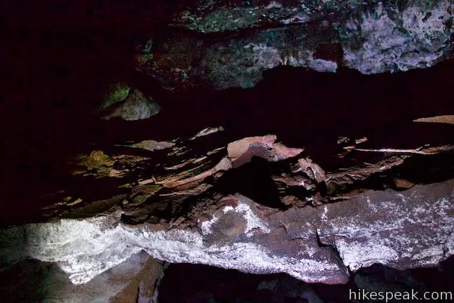
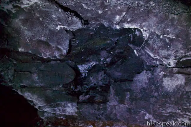
Step onto the floor of the lava tube, which has the ropy and smooth characteristics of pahoehole lava. Pahoehoe is the smoother type of lava that looks like hardened batter (instead of jagged rocks of an ‘a‘a flow). Do watch your step though, as the floor contains jagged breakdown areas where lava rock has collapsed. Move toward the back of the large room in the lava tube. Climb up a breakdown and check out the roots hanging from the ceiling of the cave. Examine the different colors of growth on the dark walls of the cave. After about 100 yards, the room shrinks to a narrow passage below a cave breakdown. Beyond this point, the cave opens up again before another breakdown that makes passage difficult. Explore what you wish, or simply enjoy the first large long room on the north side of the Kaumana Caves lava tube. Make your way back up and out into the open air by the staircase. 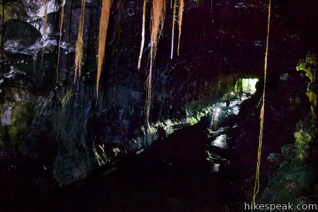
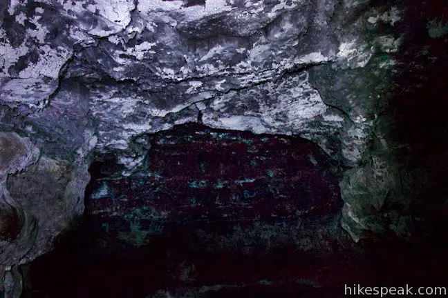
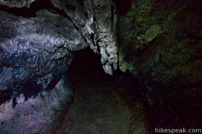
South of the entrance for Kaumana CavesTurning left at the bottom of the stairs leads to the smaller of the two entrances. This cave opening is about a quarter the size of the other one and more difficult to access. Make your way down a makeshift staircase over chunky boulders from the cave breakdown that exposed the lava tube. Once you get inside the cave and are standing firmly on the cave floor, notice a new obstacle ahead. A shelf of lava rock sits right across the middle of the cave, dividing it off into upper and lower areas. At first, it might look like there’s no where to go. Duck under the shelf and scooch your way to the other side. Beyond the barrier, you’ll be able to stand easily again inside a long, relatively narrow lava tube. 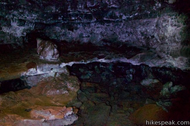
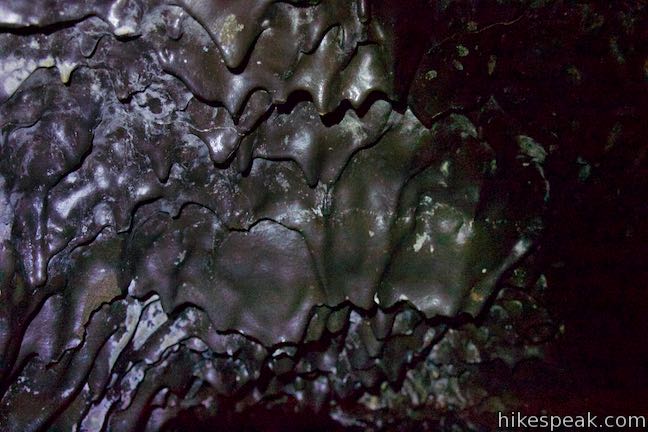
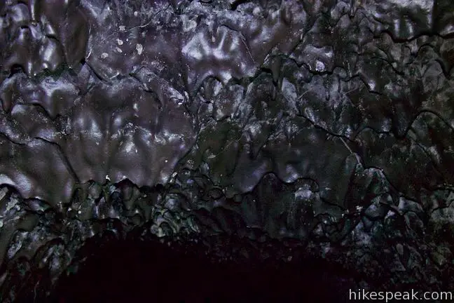
After the early challenges, the walking becomes unobstructed. It is possible to travel for quite a long distance up the lava tube (or at least until the invisible boundary where the cave leaves county land for private property). As you travel into the cave, examine all the different shapes in the lava where it has cooled on the ceiling, walls, and floor. Molten lava does some fascinating things when it cools! 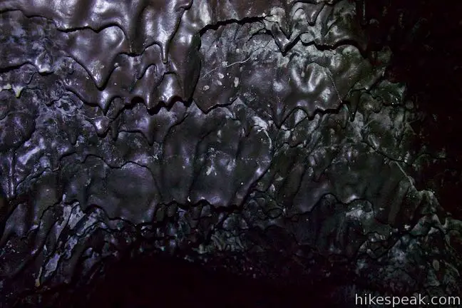
Once you have gone as far back into the cave as you’d like, or spent as much time in the dark as you care to, make your way back out of the cave and take the staircase back to the surface near the parking area. How are lava tubes created?Lava tubes channel eruptions of fluid basaltic lava (pahoehoe). When Mauna Loa erupted in 1881, the surface of the lava flow cooled first, while the lava below the crust remained molten. Like plumbing for the eruption, this tube formed below the surface and channeled lava downhill. The hardened walls of the tube insulate the lava so that it did not cool until it spilled out of the end of the tube. When the eruption stopped, and new lava was no longer entering the tube, the molten lava already in the tube continued its downhill flow, leaving behind an empty cavity.
(adsbygoogle = window.adsbygoogle || []).push({});
As the lava tube hollowed out, the 1881 lava flow halted about a mile from downtown Hilo (about 37 miles from the summit of Mauna Loa). Princess Ruth Keʻelikōlani of the Kamehameha dynasty is credited with saving Hilo from destruction. She camped in front of the lava flow and prayed to the great Hawaiian deity Pele, the creator of the Hawaiian Islands and the goddess of fire and volcanoes. In subsequent years, an area above part of the lava tube collapsed and the caves were revealed. Even when the roof of a lava tube doesn’t completely collapse to create a skylight, sections of the roof can fall, called breakdowns, which leave jagged rocks on the floor of the cave to traverse. 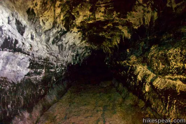
What to bring to Kaumana Caves Lava TubeSturdy footwear is recommended. Lava tubes are very dark. Bring multiple bright lights (flashlights) per person if possible. Unlike lava caves that you might encounter in the Pacific Northwest, the Kaumana Caves are warm and humid like the surface above. Pack one extra layer for safety. Kaumana Caves is managed by the Department of Parks and Recreation for the County of Hawaii. No fee is required to park at the trailhead and enter the cave, so get out and enjoy! To get to the trailhead: Take Hawaii 19 (Hawaii Belt Road) to the center of Hilo and head inland on Waiamuenue Avenue. Drive 1 mile and bear left through a split onto Kaumana Drive (don’t turn right toward Rainbow Falls). Take Kaumana Drive for 3 miles. On the outside of a major bend to the right, turn left into the parking area for the caves. A sign by the entrance of Kaumana Caves is visible on the right just before the parking area. Park and walk across the road, being cautious to avoid the traffic. Trailhead address: Kaumana Drive, Hilo, HI 96720 Use this map to view the trail and get directions:
(adsbygoogle = window.adsbygoogle || []).push({});
Photos
These photos were taken in October of 2018. Click to enlarge.
Nearby Trails
Similar Trails
from https://www.hikespeak.com/trails/kaumana-caves-lava-tube-hilo-hawaii/
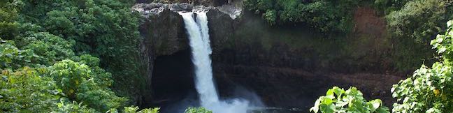
A mile and a half from downtown Hilo, the biggest city on the Big Island of Hawaii, Rainbow Falls pours over a basalt ledge in Hawaii’s longest river. The 80-foot tall waterfall takes a broad single-drop plunge. Visitors can see Rainbow Falls (and hopefully a morning rainbow) from Rainbow Falls Lookout in Wailuku River State Park, where 0.2 miles of lets-be-generous-and-call-it-hiking leads to one viewpoint facing the waterfall and another perch alongside the top of Rainbow Falls. With minimal effort and plenty of beauty as reward, Rainbow Falls belongs on every Hilo trip itinerary.
(adsbygoogle = window.adsbygoogle || []).push({});
Pull up to the parking area for Rainbow Falls Lookout, nestled within the city of Hilo, just 1.5 miles west of it’s coastal downtown. Straight ahead of the parking area is a 70-yard long viewing area facing Rainbow Falls. A paved ramp and walkway makes this area of the park wheelchair accessible. On your left as you face the waterfall, spot another trail packed with rock slab steps that rise to the brink of Rainbow Falls. 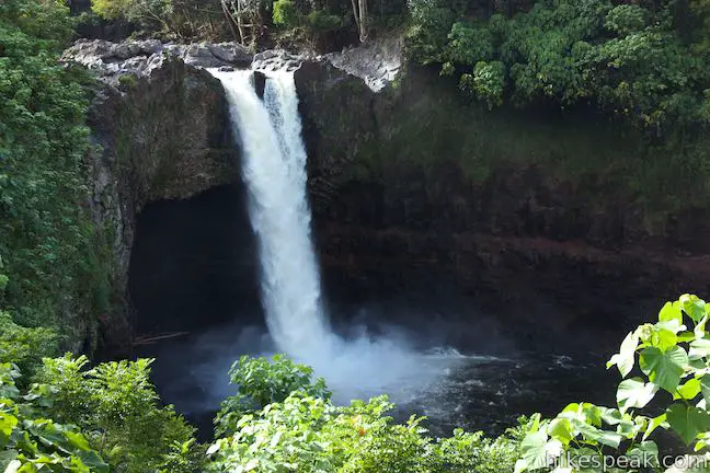
Rainbow FallsThe easiest and best way to see Rainbow Falls is from the viewpoint that is level with the parking area. Walk out and enjoy head-on views of the waterfall. A curtain of white pours over a shelf of black basalt. Sunny mornings are the recommend moments to observe the waterfall’s renown rainbows. A park info panel offers this description of the waterfall:
According to Hawaiian mythology, the cave in the overhang behind the waterfall was home to Hina, the mother of demigod Maui. A giant lizard named Kanu tried to drown Hina while she was in the cave, resulting in a epic battle with Maui in the Wailuku River. Rainbow Falls might be a shorter beauty, but the volume of the river gives the waterfall heft and significance. Once you have taken in this perspective of Rainbow Falls, backtrack toward the parking area to venture up the next trail, which is steeper and slightly longer. 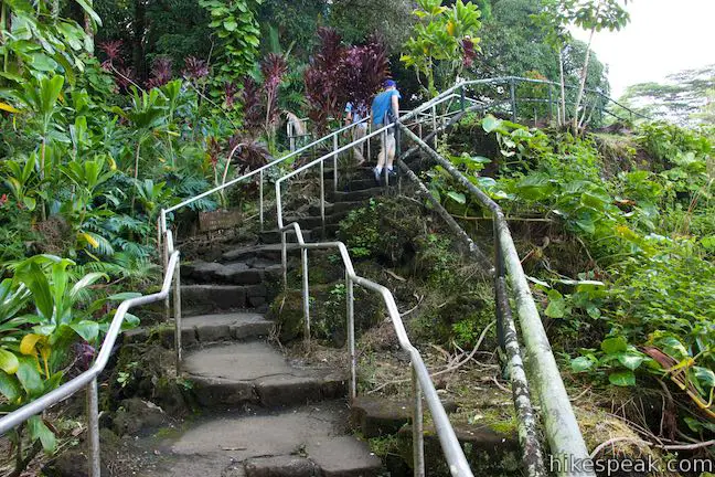
Top of Rainbow FallsLeave the parking area again and begin up rock steps that ascend the slope south of Rainbow Falls. Metal railings along the staircase assist with the climb. After around thirty steps, the trail levels out atop the basalt ledge beside Rainbow Falls. Walk up to the railing at an overlook by the brink of Rainbow Falls. Watch the waterfall pour over the edge of the jagged basalt ledge. Look down on a pool that extends to the right, below the viewing area where you just stood. Wailuku River makes its way past the pool to the left on its course to the coast. The exposed banks of the river signal just how much higher the water level can get. 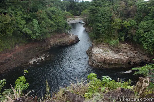
The most interesting thing about the top of Rainbow Falls might not be the waterfall itself (you get a better view from the lower viewpoint). Instead, it is the wild depressions and pools in the riverbed surrounding the top of the waterfall that draw your attention. The basalt surface is full of strange pockets and other shapes. 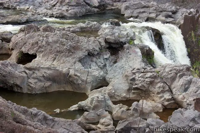
(adsbygoogle = window.adsbygoogle || []).push({});
The trail end at the top of Rainbow Falls. Footpaths continue upriver through a grove of banyan trees, but this area appears to be off limits. Flash flooding and rapid rises in the river have proven deadly, so exploring beyond the trail has risks. Once you’ve seen the top of Rainbow Falls and gazed up and down the river, follow the step-packed trail down to the parking area to complete this 0.2-mile round trip hike with 40 feet of elevation change. Dogs and bikes are not allowed on this outing. Parking at Rainbow Falls Lookout in Wailuku River State Park is free, so get out and enjoy! Boiling Pots LookoutA short distance up the river from Rainbow Falls Lookout, find Boiling Pots Lookout positioned over an area of the river made up of pools resembling boiling pots. Some people like to use these pools as swimming holes during the right conditions. Wailuku River is prone to dangerous flash floods (the translation for Wailuku is “waters of destruction”). Observe all barriers and signs.
To get to Rainbow Falls Lookout: Take Hawaii 19 (Hawaii Belt Road) to the center of Hilo and head inland on Waiamuenue Avenue. Drive 1 mile and stay right through a split with Kaumana Drive to continue up Waianuenue Avenue, following signs for Rainbow Falls. Drive another quarter mile and turn right onto Rainbow Drive. The parking area for the lookout is on the right after another quarter mile. To get to Boiling Pots Lookout, continue up Rainbow Drive and reconnect with Waianuenue Avenue. Turn right and drive 1.3 miles farther up Waianuenue Avenue. Turn right onto Pe’epe’e Falls Road. Go one block and turn left into the parking area for Boiling Pots Lookout. Trailhead address: Rainbow Falls Lookout, Rainbow Drive, Hilo, HI 96720 from https://www.hikespeak.com/trails/rainbow-falls-wailuku-river-state-park-hilo-hawaii/
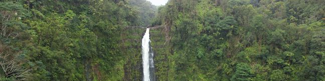
‘Akaka Falls is stunner – considered one of the most beautiful waterfalls in Hawaii – with a 442-foot single-drop into a tropical valley. This great waterfall is paired with a great viewpoint. A paved 0.55-mile long loop trail leads to a lookout in front of ‘Akaka Falls, while also providing a glimpse of 300-foot tall Kahuna Falls and several small cascades. ‘Akaka Falls is the tallest waterfall on Kolekole Stream, which flows down the north side of Mauna Kea through the rainiest area of the Big Island. Expect the waterfalls to be gushing and the vegetation to be vibrant.
(adsbygoogle = window.adsbygoogle || []).push({});
Start from a road’s end trailhead parking area in ‘Akaka Falls State Park, which has info panels and partial views of the waterfall. To really see ‘Akaka Falls, begin down the paved trail leaving the parking area. Cross a slope of tropical plants and comes to a T-junction after twenty-five yards. The shortest route to ‘Akaka Falls is to the left and you might visit the waterfall on a 1/3 of a mile out and back hike. But why not hike the full loop and see more of the forest, take a look at Kahuna Falls, and collect additional views of ‘Akaka Falls? The loop trail is a little over half a mile long with 115 feet of elevation change. Turn right to follow the recommended direction for the ‘Akaka Falls Loop Trail (which is counter-clockwise). The trail descends along the side of a lush ravine. Several flights of steps are built into the paved trail. Watch your step. Rain falls frequently in this area, so the trail surface can get slippery. Ferns and impatiens cling to the side of the valley to your right, while a stream flows down the ravine to your left. The trees all around the trail are covered in various epiphytes (plants that grow on other plants), so the surroundings are lush and jungle-like. 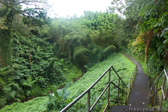
Descend to a footbridge over the small stream, which is flanked by tall stalks of bamboo. A sprawling tree above the left side of the gulch is particularly impressive. Leaving the stream, the trail passes through the bamboo to a junction. A sharp turn to the left leads to the rest of the loop. Straight ahead, it is just a few more steps to Kahuna Falls Lookout. 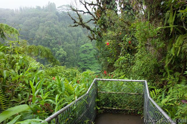
Kahuna Falls LookoutPeer out across the verdant valley carved by Kolekole Stream (downstream of ‘Akaka Falls). On the far side of the valley, look for a streak of white tumbling down the tree-covered slope. Kahuna Falls pours into the valley from a side stream. This 300-foot tall waterfall is obscured by trees, unlike ‘Akaka Falls, and harder to appreciate. 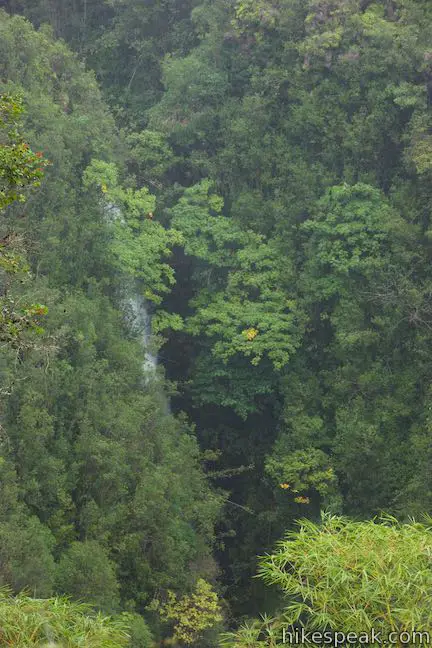
As you pause to observe the waterfall, consider how this landscape was formed, as chronicled by a park info panel:
Leave Kahuna Falls Lookout, backtrack to the junction, and continue with the loop. The paved trail climbs for a stretch, rising along a ridge between the main valley and the gulch you descended to start the loop. The vegetation remains abundant and impressive. After a short ascent, the trail levels out and turns downhill. As you begin down more stairs, the growing perspective of ‘Akaka Falls will usher you forward. 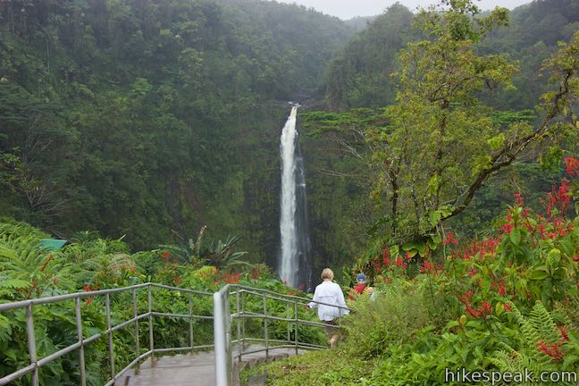
‘Akaka Falls LookoutDescend to ‘Akaka Falls Lookout, which has a shelter – should you need to get out of the sun or rain. Step up to the railing and look out at ‘Akaka Falls (the cliffs in front of the overlook are quite steep, so definitely stay behind the barriers). The 442-foot tall waterfall takes a single-drop plunge into the round pool below. ‘Akaka Falls has a straight drop beside cliffs of dark volcanic rock that are draped in green moss and ferns. Kolekole Stream begins on the upper slopes of Mauna Kea and carries lots of water over ‘Akaka Falls.The 40-story waterfall is an impressive sight! To the left of ‘Akaka Falls, you may spot a thin ribbon-like waterfall that pour down the cliffs during wet conditions, completing the sensational scene. 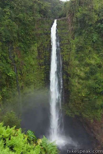
Something fishy about ‘Akaka FallsJust past the shelter, find a couple info panels that describe how one incredible fish actually climbs up ‘Akaka Falls to swim in the stream above. To make their way up the swift stream and climb the wall of the waterfall, a goby fish called the ‘o‘opu ‘alamo‘o uses more than just powerful fins. The fish rely on suction disks on their undersides (ventral sides) to combat currents and climb steep, slick surfaces. The panel explains:
The ‘o‘opu ‘alamo‘o swim two and a half miles up Kolekole Stream and then the five-inch long fish climb over four hundred feet up the slick cliffs against the flow of ‘Akaka Falls to reach the stream above where they can live out adulthood. What a journey!
Female ‘o‘opu are tan or olive in color, while males can turn black and orange when they need to impress. In addition to this fish, a shrimp called the ‘ōpaekala‘ole is also able to climb the waterfall. These amphidromous shrimp are also born in Kolekole Stream and swept away to the ocean to grow as larvae before returning to the stream. 
(adsbygoogle = window.adsbygoogle || []).push({});
‘Akaka Falls Loop TrailSpend ample time admiring ‘Akaka Falls. Then leave the lookout shelter and continue with the loop trail. If stepping away from the beautiful waterfall gets you down, fret not; the trail does its best to keep your spirits high by passing several smaller cascades. Study these streams and you may spot an ‘o‘opu fish ascending one of the branches off Kolekole Stream (apparently trying to avoid the big waterfalls). The tropical vegetation along the trail is lush and flowering. The green leaves of philodendron are accented by impressive red blooms of lobster claw heliconia. The red-tipped leaves of ti plants thrive along the trail too. Admire the diverse plant life, which is almost completely non-native. As the din of the waterfall fades away, listen for singing birds. This area of the Big Island is home to several uniquely adapted Hawaiian birds like ‘i‘wi, ‘amakihi, ‘apapane, and ‘elepaio. 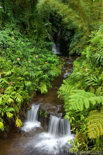
Cross a second creek, a tenth of a mile from ‘Akaka Falls and half a mile from the start. Admire cascades that are both upstream and downstream from the bridge. Across the bridge, the trail turns left and rises along a fern-covered slope. To your left is a new perspective down the gulch that you explored on the way to Kahuna Falls Lookout. Make your way up to the junction where the loop began. Bear right and walk back to the parking area. 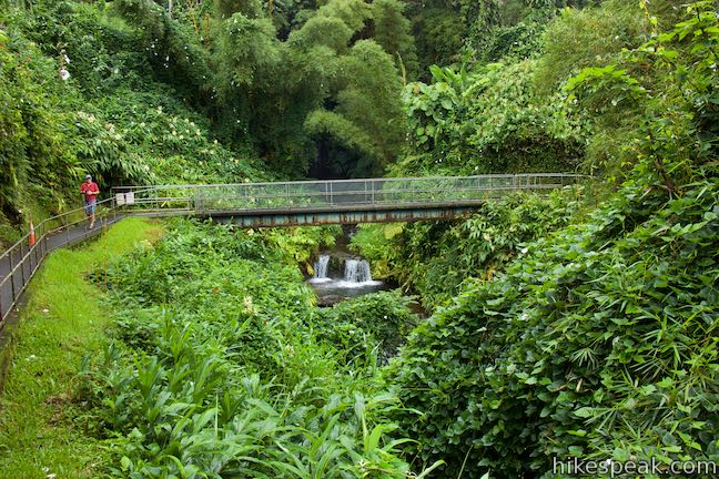
Although no hiking permit is needed for this short loop, ‘Akaka Falls State Park does charge an entrance fee, which is $5 per vehicle or $1 per person for those who arrive by bike or on foot. Hawaii residents may visit the park without charge. The fee can be paid an electronic kiosk or with the assistants of a park attendant. Bathrooms are located at the trailhead. Bikes and dogs are not allowed on this hike. The parking area in ‘Akaka Falls State Park is open from 8:30 a.m. to 6 p.m. To get to the trailhead: From Hilo, Taka Hawaii 19 (Hawaii Belt Road) north for 11 miles. Following signs for Akaka Falls, turn left up Honomu Road (on the mauka side of the road). Drive 0.4 miles up to the town of Honomu. Turn left and then make the second right onto State Highway 220 (Akaka Falls Road). Drive another 3.3 miles to the trailhead parking area at road‘s end. Coming from Waimea, travel 43.5 miles east on Hawaii 19 (Hawaii Belt Road) to the intersection with Honomu Road that leads up to Akaka Falls Road. Trailhead address: Kiholo Bay Parking, Akaka Falls Road, Honomu, HI 96728 from https://www.hikespeak.com/trails/akaka-falls-hike-hawaii/ |


 RSS Feed
